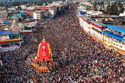
At the end of October 2025, a number of districts in peninsular India, during the northeast monsoon phase have been put on high weather warnings. The IMD has issued orange codes in sections of Karnataka, Kerala and Tamil Nadu, coastal Maharashtra-including Mumbai is also on message of thunderstorms and moderate rain. According to recent bulletins, a channel moving towards the south of the states, formed over the Bay of Bengal is the low-pressure area that probably is to push moisture and convection into the area.

These are not isolated weather anomalies. They are part of an overall trend: the retiring southwest monsoon has been replaced by the northeast monsoon, presenting new challenges to urban regions, mountainside areas and farmland. As India becomes a merger of geography, economy and climate, this rain episode has been a wakeup call to the fact that monsoon season does not just end in September.
This paper will discuss the weather conditions that triggered the disaster, the immediate hazards, the local impacts, and the strategic lessons to enable India to manage the dynamics of the shifting climatic conditions.
The Meteorology Never Behind the Alerts
Monsoon Transition and Active Systems
The monsoon that washes the southwest of India generally forms the basis of the rain story in India between June and September. But in the peninsular region the northeast monsoon (NEM) or retreating monsoon sets in by mid-October and may bring heavy rains to Tamil Nadu, Kerala, coastal Andhra and south interior Karnataka. The bulletin of the IMD states that the NEM had started across Tamil Nadu, Puducherry, coastal Andhra, Rayalaseema and south interior Karnataka by 16 October.

At the same time, IMD reports indicate that there is an upper-air cyclonic circulation in the southeast of the Bay of Bengal and the adjoining south Andaman Sea up to the middle levels of troposphere. Given this impact, there are high chances that a low-pressure area will develop on 24 October over the southeast and the adjacent east-central Bay. This system will travel west-north-westwards.
Forecast Conditions: Thunderstorms, Sea Affects, Heavy Rain
- As of 24 October, an official IMD “All India Weather Summary and Forecast Bulletin” had the following:
- Light to moderate rainfall/thunderstorm forecasted in most of the south peninsular India (Tamil Nadu, Kerala, Karnataka) and isolated very heavy rainfall in Kerala and Mahe and Coastal Karnataka on 24 October.
- During the next few days (25-28 October) intense precipitation is expected over areas of Andhra Pradesh and Yanam, Rayalaseema, and once again Kerala and Mahe.
- Lightning thunderstorms and strong winds (30-40 km/h or more) should be expected in several southern states.
- Others predict heavy, even very heavy rainfall at some locations in Andhra, Tamil Nadu, Kerala, Karnataka with sporadic extremely heavy rainfall.
Why Now? Soil Saturation, Terrain and Season Wind Patterns
Various issues are increasing risks this time:
- The soil wetness profile along the coast and the hilly topography can be high in advance due to previous monsoon spells, that is, surface runoff and flash floods have an increased probability of occurrence during the occurrence of strong rainfall.
- The terrain features in coastal Karnataka, Kerala and Tamil Nadu (western ghats, steep slopes, narrow coastal plains) increase the risk of heavy rainfall by yielding landslides and causing the rapid overflow of the drainage streams.
- The easterly/ northeasterly circulation linked to the NEM brings rainfall from the Bay of Bengal and the Andaman Sea to the southern peninsula-the moisture transportation, in conjunction with the domestic motion (such as the area of low pressure) enhances rainfall.
- The centers of the urban areas, low regions, and flood-prone river basins are particularly susceptible.
Areas of Concern and Risk Areas
Coastal Area & Hilly Districts of Kerala and Karnataka
IMD has given orange level warnings to districts like: Kasaragod, Kannur, Kozhikode, Wayanad and Malappuram in Kerala– and Uttara Kannada, Udupi and Dakshin Kannada in Karnataka.

Risk profile:
- Landslides and mud-slides become a real threat after a heavy rainfall and this is mostly in a hilly land (e.g. Wayanad, Malappuram).
- The rapid rise of water level, inundation of coast, strong winds and waves might be observed in the coastal districts (Udupi, Dakshin Kannada).
- The local infrastructure (roads, bridges, drainage) can be stress-tested.
Chennai and Kanyakumari Tamil Nadu Coastal Belt
According to the IMD, it is quite possible that in the next 3 hours, there might still exist light to moderate rainfall in some places across Chengalpattu, Chennai, Kanyakumari, Ranipet, Tenkasi, Thiruvallur, Tirunelveli.
Risk profile:
- The flooding of urban regions in Chennai, coastal and peri-urban areas with significant downpours and drainage limitations.
- The sea + rainfall may overflow in low-lying coastal regions (Kanyakumari peninsula).
- During lightning and thunder storms, traffic, transport and power disruption.
Reading in Mumbai Metro and Konkan Coast
These are relatively outside the high end very heavy rain alerts; but Mumbai, Thane, Palghar are on a yellow thunderstorm, moderate rain and lightning alert.

Risk profile:
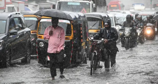
- Flooding, gridlock and waterlogging have been gaps in urban drainage in Mumbai; even average intense precipitations can result in flooding, traffic lockup, and waterlogging.
- In the case of thunder-storm risk, trees, power lines and elevated sea levels along the coast are of concern.
Impacts: Strategic and implementational
Immediate Impacts
- Urban chaos: Inundated roads, gridlocks, delays in the Metro/rail, power outages are expected in Chennai, Mumbai and the coastal Karnataka.
- Agricultural Stress: Certain of the crops in these states rely on the receding mono-soon and uncertainties of heavy rain can ruin harvests or postpone the planting of crops with short growth cycles.
- Landslides and Flash Floods: In hilly areas of Kerala and Karnataka, there is the risk of landslides, failures of hillsides slope, and limited flash floods due to excessive rainfall. IMD has specifically indicated flash-flood risk.
- Coastal & Marine Hazards: It is important to keep the alert, fishermen and marine operations may realize sea storms, there are some wave levels, contradicting eyes: Lightning risks are real. The predictions warn about going to sea.
Wider Strategic Conclusions
- Cities: An increasing number of cities are facing monsoon rainfall shocks of off-monsoon rainfall. Such transitional-monsoon risks should be factored out to drainage, storm-water management and flood mitigation planning.
- Water Management: The amount of heavy rainfall during a short duration of time might not be transformed into positive infiltration or ground water recharge. Instead of water being lost, it may mean rapid runoff and spill-over. This requires a quicker operational reaction of states operating reservoirs, rivers and irrigation systems.
- Climate Adaptation: Due to the occurrence of heavy rain during a period that is not classified as the monsoon season is evidence of climate variability. These changing trends must be included in the disaster-management systems, weather forecasting, early-warning and community preparedness of India.
- Policy & Infrastructure: Now we have an opportunity to consider the sufficiency of early-warning mechanisms, local governance action, hillside land-use controls, coastal zone management, and expenditure on robust infrastructure.
Recommendations to Stakeholders: What Can Be Done
In case of Government and Disaster Agencies
- Turn on district disaster management commanding in any orange alert areas and liaise with state agencies to assist in quick response.
- Pre-position pumps, makeshift shelters, rescue equipment (in hilly areas, inaccessible areas particularly in the remote ones) and have round-the-clock surveillance of rivers, dams, and low areas.
- Make public announcements effectively (through local media, social media, cell phone notices) to request communities not to engage in unneferred traveling, keep off river-banks and hill sides during strong rain, and to pad structures against the winds.
- The cities of Chennai, Mumbai, Bengaluru etc should verify drainage lines, unblock storm-water pipes, anticipate traffic jams, and have power reserve of emergency systems.
- In coastal and marine areas: issue fishermen warnings, postpone the high-risk sea work, watch the waves and the wind forecasts.
For Businesses
- Transportation and supply-chain companies are advised to check the routes along the affected regions (coastal Karnataka, Kerala, Tamil Nadu) on potential disruptions, particularly when there are intense rain periods (24-28 October).
- Power outages, network disruptions, clearing up of rubble and storm damage should all be planned by infrastructure companies (electricity, telecom, roads).
- Workplaces located in risky urban areas must implement flexible work hours or telecommuting whenever heavy rains are experienced.
- Agricultural businesses ought to reexamine crop-protection plans, particularly of crops reliant on this monsoon season, of brief periods.
On behalf of citizens and communities
- Follow official bulletins on weather- conditions- be attentive when IMD puts out orange alerts. These are not routine rain forecasts but carry warnings of increased danger.
- In areas where there are hills or areas prone to flooding, know their safe areas beforehand, carry emergency kits and people in ground/low-rise areas should be conversant with emergency evacuation plans.
- Should not cross flooded roads or streams, should never shelter under trees in thunderstorms, should not stay at home, should not stay in an open field.
- City dwellers: use safe balconies and terraces, ensure there is a clear water-outlet, keep electronic appliances safe, do not park under low trees or big trees, and should be wary in a vehicle/travel.
- Communities/fishermen on coastal areas: pay attention to instructions regarding sea conditions and do not go out at the time it is recommended.
A Long-Term Perspective: Why These Rainfall Events are important to the future of India
The episode of the rainfall alerts is not just another temporary weather report, but an entire captivation of the intersection point of geography, climate changes, urbanization and socio-economic development in India.

Monsoon Quagmires and Enhanced Unpredictability
Conventional trends are evolving. The southwest monsoon has been postponed, northeast monsoon also being more active, and the windows, which would thus far be regarded as off-peak, are getting influxed with heavy rain. The timing and intensity of changes are systemic risks to a nation such as Thailand that relies heavily on monsoons. The summary of the IMD noted categorically that the incidence of isolated very heavy rainfall which were previously not included in the forecast is currently incorporated in the predictions in the southern peninsular India.
Urban India Under Pressure
Chennai and Mumbai were not constructed to endure countless disasters caused by monsoons. In rapid urban development, the improvements on infrastructure, such as drainage, storm-water storage, buffers around green belts and slope control on hilly areas, have been left wanting. The same can be observed in the recurrent floods in Chennai (2015) and the project of water-logging in the city of Mumbai. When the heavy spells recur, the economic cost, comprising the direct damages, commercial disturbances, productivity loss and transport paralysis increases.

Rural and Agrarian Stress
The agricultural systems in southern India rely on the NEM rains to water some crops and groundwater refilling in the peninsular zone. Nonetheless, intensive downpours within short periods may harm crops, lead to soil erosion, and take away seedlings and disrupt the harvest logistics. When there is poor infiltration and high runoff chances are that the surplus water will not be harvested. In the long run, this destroys the resilience of the agrarian societies that are already faced with market fluctuations, the cost of inputs and climate uncertainty.
Disaster Governance and Risk
Disaster preparedness is no longer an option, it has become a necessity. Alerts such as orange imply that governance institutions, such as district collectors to panchayat disaster committees, should be on the offensive. As the weather swings more and more extreme, the weather management needs to be anticipatory rather than responsive to the disaster. That involves investment in early-warning, strength infrastructure (in hills/coast in particular), land-use regulation (no building on slopes that may end up unprotected), and community education messages.
Climate Response in India
The climate adaptation agenda in India needs to pay more attention to extreme downpours, but not drought and heat only. Establishing resiliency to high rainfall is equivalent to hedge-funding rainfall risk: drainage system, floodplain planning, slope stabilisation, coastal sea-protective, urban catchment planning, rainwater harvesting on peak rainfalls, and adaptive farm-calendras. Provided India is actually able to develop infrastructure and policies that are resistant to, and not simply responsive to, the growing erratic precipitation patterns, it will gain more leverage both locally and in the world climate talks.
Looking Ahead: What to Watch
- Monitoring the low pressure area: The low-pressure region that is developing over the Bay of Bengal on 24 October is a hot spot. In the event it deepens or shifts in a different direction, the distribution of rainfall might change (say it occurs more inland in Karnataka or Andhra and less in the coasts).
- Status of the river catchment and dam/reservoir operation: As the heavy rain starts, the inflows to the reservoirs can increase. The release procedures should be coordinated to prevent the downstream flooding.
- Slope and land slide warnings: During rainfalls in Kerala and Karnataka the rainfall in brief spells of rain could be violating tipping points- observe slope releases, mud-slides, blockage of roads.
- Urban flash-flood areas: The rainfall intensity to be crossed to flood in Chennai, Mumbai and coastal cities in Karnataka, due to the reduced open grounds and more impervious surfaces, might be less than that experienced in previous years.
- Adaptive agricultural responses: Farmers in Tamil Nadu, Kerala and Karnataka have to realign the timing of sowing/harvest and drainage layout of the harvest fields as well as protection of the plantations (tea, coffee, spices) or short-season crops.
- Public awareness, Communication: With changing monsoon patterns, the people should remain sensitive to alerts (orange, red) and the local government should be able to disseminate the information effectively, particularly in rural and remote, tribal regions.
Conclusion
There are no ordinary rain forecasts that the IMD puts out in late October 2025 throughout southern India. They connote both a joining of seasonal shifts, energetic system individualities and site sensitive risks. This is an incident that India must consider when it reflects on how the rain may be very much strategic an occurrence instead of happening by; as well as the nature of the occurrence and the irregularities involved in this case.
To the audience of The Vue Times, in which general knowledge is mixed, national events, science and climate, and urbanizing infrastructure, urbanizing farming, city governance, and city safety, this episode provides various perspectives: meteorology, climate resilience, urban infrastructure, agricultural adaptation, government involvement and citizen safety. The lesson is obvious: it is a matter of preparation. Weather alerts are not alarms to be overlooked but signals on the part of nature to indicate that the resilience architecture of India needs to act before it is too late.
Increased rainfall in an economy where water is a blessing and a threat, the price of doing nothing is high. Rainfall risk is a national challenge that needs attention: the drainage of cities, the landscape planning of hills, the design of farm fields, coastal protection work, it is time to put the nation through its paces.