The ocean is vast, ever-shifting, and richly layered with activity: commercial ships, fishing boats, submarines, patrol vessels, environmental sensors, and more. In the space above that sea lies an equally complex realm of satellites, signals, communications and command centres. It is in the meeting of these two domains–space and sea–that India’s latest strategic leap takes shape. With the launch of GSAT-7R (also referred to as CMS-03) by the Indian Space Research Organisation (ISRO), India is setting up a major new link in its maritime domain awareness (MDA) architecture–giving it sharper eyes, faster connections, and wider coverage over the Indian Ocean Region (IOR).
In the following sections, we’ll explore the why, what and how of GSAT-7R: the background of maritime domain awareness, the satellite’s capabilities, its strategic importance, and the challenges and implications ahead.
Why Maritime Domain Awareness Matters
To appreciate the significance of GSAT-7R, one must first understand what is meant by “maritime domain awareness”. Broadly, MDA refers to the ability to comprehensively monitor, understand and respond to events or activities in the maritime environment. This includes surface vessels, sub-surface assets, airborne platforms, ports, littoral zones, commercial shipping lanes, environmental hazards, smuggling or piracy operations, as well as benign and malicious behaviour at sea. A publication from India’s DRDO notes that “without understanding maritime domain one cannot protect it from innumerable threats.”
DRDO

India’s geostrategic position–surrounded by the Indian Ocean, with maritime trade routes, energy flows, fishing zones, and naval interests–makes an effective MDA system imperative. The country has invested in coastal radars, automatic identification systems (AIS) on ships, long-range UAVs, maritime patrol aircraft, and increasingly satellite assets to feed data into regional operations centres. For example, radar and satellite feeds feed into the Information Management and Analysis Centre (IMAC), helping produce a unified operational picture of the IOR.
However, the maritime environment is challenging: vast distances, limited line-of-sight infrastructure, multi-domain platforms (surface, sub-surface, aerial), and the need for secure, real-time communications among widely dispersed assets. This is where space comes in: satellites can cover vast oceanic tracts, provide persistent connectivity, link ships and submarines to command centres, and interconnect airborne and surface platforms.
The Journey to GSAT-7R
India entered the dedicated military communications-satellite domain with the launch of the first GSAT-7 (also known as “Rukmini”) back in 2013.

That satellite provided UHF, S-band, C-band and Ku-band service over the Indian Ocean Region, enabling real-time networking of naval assets. But over a decade later, technology and requirements have evolved: the number of platforms to interlink has grown, data volumes have increased dramatically, adversarial threats have become more complex, bandwidth needs have risen, and the Navy’s commitment to blue-water operations has expanded.

Therefore, GSAT-7R was conceived as the next generation–more capable, higher bandwidth, multi-band, and designed to operate across an even wider geographic scope with better resilience and encryption. Contracted in June 2019, it represents ISRO’s push into heavier payloads and the Navy’s push for better connectivity.
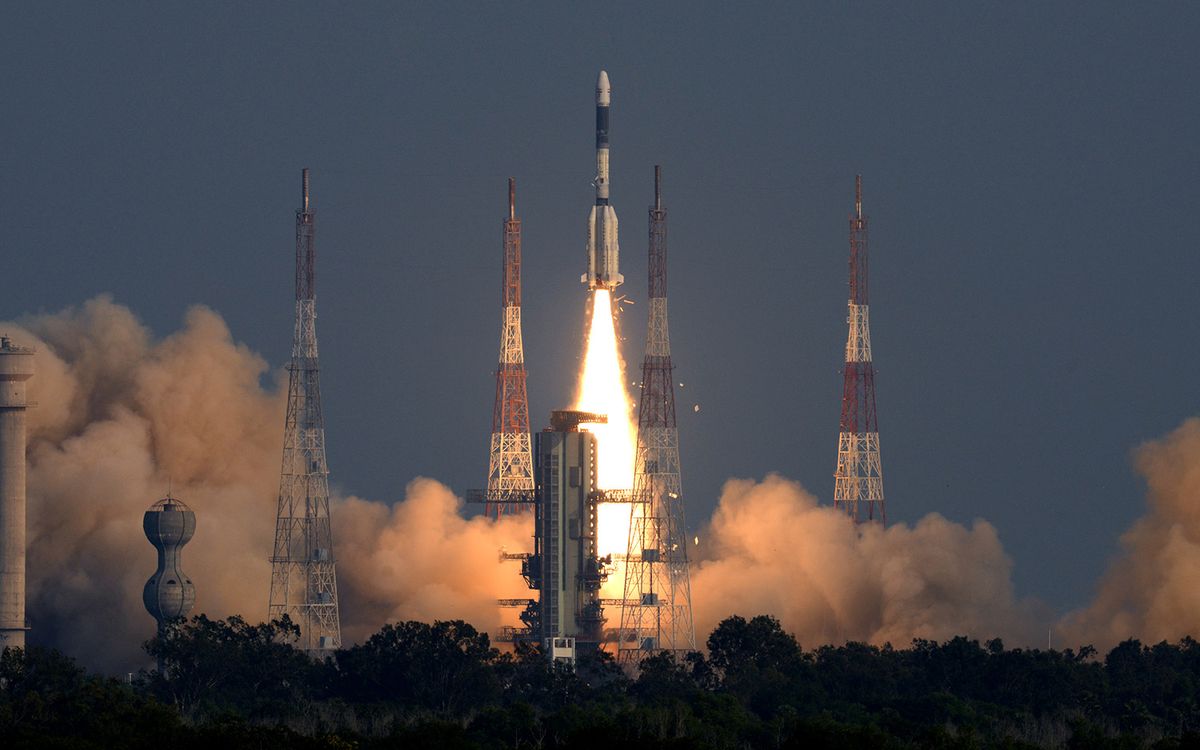
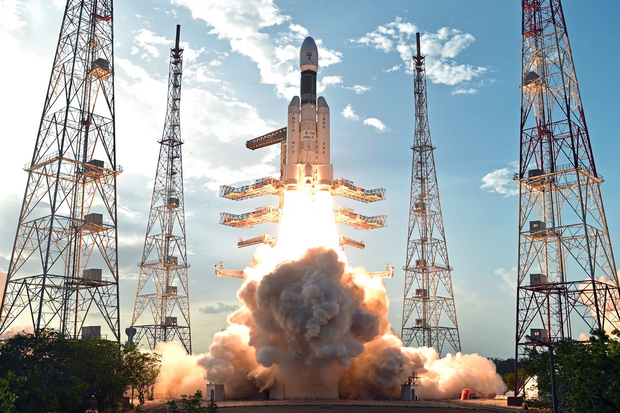
On 2 November 2025, ISRO successfully launched the satellite aboard the LVM3-M5 (also known as “Bahubali”) from the Satish Dhawan Space Centre, Sriharikota. The satellite weighed approximately 4,410 kg–making it India’s heaviest communication satellite to date.
Capabilities & Technical Features

While many details are classified, publicly available information provides a clear picture of the enhanced capabilities GSAT-7R brings to the table:
Multi-band payloads: GSAT-7R features C-band, extended C-band, Ku-band and perhaps UHF/S-band links for secure voice, data and video transmissions. It sits at the intersection of high-throughput communications and resilient, resilient maritime links.
India Today
Wide coverage footprint: The satellite’s coverage includes the Indian landmass and stretches deep into the Indian Ocean Region–thus providing persistent space-based connectivity for naval assets deployed far from the coast.
AP7AM
Higher bandwidth/resilience: Compared to its predecessor, GSAT-7, GSAT-7R brings significantly enhanced communications capacity, stronger encryption, better mobility support (ships, submarines, UAVs, aircraft) and likely anti-jamming characteristics.
Business Standard
Network-centric operations: With ships, submarines, aircraft and shore-based command centres all interlinked, GSAT-7R acts as a backbone enabling “fleet as a node” concept in the Indian Navy’s operations. The idea is real-time linking of assets, sensors and decision systems.
Support for MDA: The satellite plays a key role in maritime domain awareness by facilitating data exchange from sensors (AIS, radars, UAVs, maritime patrol aircraft) and ensuring that this data reaches the right command centres in near real-time.
In short, GSAT-7R is not just a “communications satellite”; it is a strategic enabler–a space-borne link that knits together maritime, aerial and land-based assets into a cohesive, responsive operational grid.
Strategic Importance for the Indian Ocean Region
Why is this significant? There are several dimensions:
Strengthening India’s maritime posture
With a modern navy increasingly operating beyond near-coastal waters in the Indian Ocean Region, having robust communications and surveillance support is vital. GSAT-7R enables extended reach, faster coordination, and better situational awareness–key for deterrence, expeditionary operations, anti-piracy, maritime diplomacy and disaster response.
Indigenous capability and strategic autonomy
By developing the satellite domestically and launching it with the heavy-lift LVM3, India reduces its dependence on foreign launchers and systems. This fosters strategic autonomy in a domain (space – maritime) that is increasingly contested.
Resilient and secure communications
In naval operations, connectivity is not a luxury but a necessity. Ships, submarines and aircraft must share sensor data, track targets, communicate with command centres and each other. In a contested maritime environment where adversaries may attempt to jam or intercept communications, satellites like GSAT-7R provide a secure and resilient layer.
Supporting the broader MDA architecture
GSAT-7R is a critical node in India’s layered MDA infrastructure: coastal radars, AIS, UAVs, maritime patrol aircraft, satellites and analytics centres. It helps feed data into the Information Management & Analysis Centre (IMAC) and other regional centres so that India’s maritime domain awareness is both deep and wide.
Modern maritime operations are inherently “network-centric” — sensors, shooters and decision-makers must be connected. GSAT-7R helps integrate platforms which may be widely dispersed (for example, a submarine in the Indian Ocean, an aircraft carrier group in a distant sea lane, a UAV monitoring littoral activity) into a coherent operational picture.
Operational Impacts & Use-Cases
To bring this to life, consider a few plausible scenarios:
-
Submarine-surface coordination: A submarine operating in deep ocean can send encrypted status updates to a surface ship via GSAT-7R communications, while that ship relays sensor data to the maritime operations centre. The result: the submarine’s mission is coordinated effectively within the fleet’s broader operation.
-
Blue-water patrols far from shore: When a naval task-force enters a remote sector of the Indian Ocean far from terrestrial links, GSAT-7R ensures that the group remains connected to headquarters. Any sensor event (for example, a suspicious vessel) can be rapidly relayed and responded to.
-
Maritime disaster relief and humanitarian assistance: In the aftermath of a cyclone or tsunami affecting remote islands or maritime zones, ships, aircraft and UAVs need to coordinate with shore centres for logistics and relief. GSAT-7R adds a reliable communication layer facilitating rescue and relief coordination.
-
Monitoring shipping lanes and A2/AD zones: In strategic chokepoints (such as the Arabian Sea, Bay of Bengal, or the Indian Ocean’s key sea-lanes) GSAT-7R can help link sensor platforms monitoring commercial shipping, identify anomalous behaviour (for example, dark vessels, potential smuggling or illegal fishing) and feed that into analysis centres for actionable intelligence.
-
Interoperability between assets: With multiple bands and high throughput, GSAT-7R facilitates integration of unmanned aerial vehicles (UAVs), maritime patrol aircraft, warships, and possibly allied assets into a shared network—important in multi-national exercises or coalition operations.
Challenges and Considerations
While GSAT-7R is a major leap forward, implementing its full potential involves several challenges:
-
Sensor and data integration: Having the satellite link is one piece; integrating all underlying sensor platforms (AIS, radars, sonars, UAVs, satellites) into a coherent network is complex. Ensuring interoperability, real-time data flow and decision support remains a challenge.
-
Cyber and electronic threats: As maritime communication becomes more networked and reliant on satellites, risks of jamming, spoofing, cyber-intrusion increase. Robust encryption, anti-jamming techniques, resilient architectures will need to keep pace.
-
Sustaining coverage in contested environment: In high-threat zones, satellites can become high-value targets (jamming, denial, physical attack). Ensuring redundancy, fallback links and resilient operations is necessary.
-
Supply-chain and technologies: Developing state-of-the-art multi-band communications, integrated maritime networks and heavy-lift launchers is technically challenging and budget-intensive—but GSAT-7R’s success with the heavy-lift LVM3 is a strong positive.
-
Operationalizing data into decisions: Having big picture situational awareness is one thing; turning that into timely, informed operational decisions is another. Training, doctrine, command structures must evolve alongside the technology.
The Bigger Picture: India’s Maritime Strategic Landscape
India’s launch of GSAT-7R comes at a time when the Indian Ocean is seeing rising strategic competition. Several factors underscore the importance of enhanced maritime domain awareness:
-
China’s increasing presence in the Indian Ocean Region (via ports, bases, submarines)
-
The criticality of sea-lanes for India’s trade, energy supplies and food supply chain
-
Environmental challenges: climate change, sea-level rise, shipping accidents, marine pollution which require maritime surveillance
-
The rise of non-state threats: piracy, smuggling, illegal fishing, human trafficking, terrorism via the sea
-
India’s ambition for a “blue water” navy and leadership in the Indo-Pacific region
In this context, GSAT-7R is an enabler of India’s strategic ambitions: ensuring secure communications, enhancing awareness, enabling reach and building deterrence. It also aligns with the national goal of “Atmanirbhar Bharat” (self-reliant India) in critical defence and space capabilities.
Future Trajectory and Connective Technologies
GSAT-7R will not stand alone. Its true value will be magnified when integrated with other platforms and future developments:
-
Complementary satellites and constellations: Other dedicated defence communication satellites, earth observation satellites, and perhaps maritime-dedicated small-sat constellations will broaden coverage and persistence.
-
Unmanned platforms and sensor networks: UAVs, underwater autonomous vehicles, buoy networks, space-based radars and AIS will feed the data that GSAT-7R helps transmit.
-
AI/ML-enabled analysis centres: Big data from maritime sensors will require real-time processing, threat analytics and actionable intelligence. The link between sensors, satellite networks and decision-makers is key.
-
Inter-operability with partners: India’s collaboration with maritime partners and regional capacity-building will benefit from robust satellite communication, enabling information sharing and joint operations.
-
Launch vehicle and satellite manufacturing maturity: The heavy-lift LVM3 success means India is increasingly capable of launching larger strategic satellites domestically—opening pathways for next-gen systems.
Conclusion: A Sea of Possibilities
More Read

GSAT-7R is more than a technical achievement; it is a strategic bridge between India’s maritime ambitions and its space capabilities. By enabling secure, high-capacity communications across the seas, linking ships, submarines, aircraft and shore commands, the satellite helps India operate as a networked maritime actor in an increasingly contested ocean theatre.
It underscores that space is not simply a domain to observe Earth—it is a domain that can actively shape operations on the sea. The Indian Ocean is not just a theatre of trade and transit; it is a domain of security, geopolitics and opportunity. GSAT-7R ensures India is connected, responsive and resilient in that domain.
In the coming years, as sensor networks proliferate, data volumes grow and maritime threats evolve, the value of that satellite link will only grow. And as the Indian Navy, coastal command structures and regional partners all plug into this networked maritime ecosystem, India’s maritime domain awareness will become sharper, more complete and more actionable. In short: space has met the sea—and the Indian Ocean is the better for it.
Enabling network-centric warfare and multi-domain operations
Modern maritime operations are inherently “network-centric” — sensors, shooters and decision-makers must be connected. GSAT-7R helps integrate platforms which may be widely dispersed (for example, a submarine in the Indian Ocean, an aircraft carrier group in a distant sea lane, a UAV monitoring littoral activity) into a coherent operational picture.
Operational Impacts & Use-Cases
To bring this to life, consider a few plausible scenarios:
Submarine-surface coordination: A submarine operating in deep ocean can send encrypted status updates to a surface ship via GSAT-7R communications, while that ship relays sensor data to the maritime operations centre. The result: the submarine’s mission is coordinated effectively within the fleet’s broader operation.
Blue-water patrols far from shore: When a naval task-force enters a remote sector of the Indian Ocean far from terrestrial links, GSAT-7R ensures that the group remains connected to headquarters. Any sensor event (for example, a suspicious vessel) can be rapidly relayed and responded to.
Maritime disaster relief and humanitarian assistance: In the aftermath of a cyclone or tsunami affecting remote islands or maritime zones, ships, aircraft and UAVs need to coordinate with shore centres for logistics and relief. GSAT-7R adds a reliable communication layer facilitating rescue and relief coordination.
Monitoring shipping lanes and A2/AD zones: In strategic chokepoints (such as the Arabian Sea, Bay of Bengal, or the Indian Ocean’s key sea-lanes) GSAT-7R can help link sensor platforms monitoring commercial shipping, identify anomalous behaviour (for example, dark vessels, potential smuggling or illegal fishing) and feed that into analysis centres for actionable intelligence.
Interoperability between assets: With multiple bands and high throughput, GSAT-7R facilitates integration of unmanned aerial vehicles (UAVs), maritime patrol aircraft, warships, and possibly allied assets into a shared network–important in multi-national exercises or coalition operations.
Challenges and Considerations
While GSAT-7R is a major leap forward, implementing its full potential involves several challenges:
Sensor and data integration: Having the satellite link is one piece; integrating all underlying sensor platforms (AIS, radars, sonars, UAVs, satellites) into a coherent network is complex. Ensuring interoperability, real-time data flow and decision support remains a challenge.
Cyber and electronic threats: As maritime communication becomes more networked and reliant on satellites, risks of jamming, spoofing, cyber-intrusion increase. Robust encryption, anti-jamming techniques, resilient architectures will need to keep pace.
Sustaining coverage in contested environment: In high-threat zones, satellites can become high-value targets (jamming, denial, physical attack). Ensuring redundancy, fallback links and resilient operations is necessary.
Supply-chain and technologies: Developing state-of-the-art multi-band communications, integrated maritime networks and heavy-lift launchers is technically challenging and budget-intensive–but GSAT-7R’s success with the heavy-lift LVM3 is a strong positive.
Operationalizing data into decisions: Having big picture situational awareness is one thing; turning that into timely, informed operational decisions is another. Training, doctrine, command structures must evolve alongside the technology.
The Bigger Picture: India’s Maritime Strategic Landscape
India’s launch of GSAT-7R comes at a time when the Indian Ocean is seeing rising strategic competition. Several factors underscore the importance of enhanced maritime domain awareness:
China’s increasing presence in the Indian Ocean Region (via ports, bases, submarines)
The criticality of sea-lanes for India’s trade, energy supplies and food supply chain
Environmental challenges: climate change, sea-level rise, shipping accidents, marine pollution which require maritime surveillance
The rise of non-state threats: piracy, smuggling, illegal fishing, human trafficking, terrorism via the sea
India’s ambition for a “blue water” navy and leadership in the Indo-Pacific region
In this context, GSAT-7R is an enabler of India’s strategic ambitions: ensuring secure communications, enhancing awareness, enabling reach and building deterrence. It also aligns with the national goal of “Atmanirbhar Bharat” (self-reliant India) in critical defence and space capabilities.
Future Trajectory and Connective Technologies
GSAT-7R will not stand alone. Its true value will be magnified when integrated with other platforms and future developments:
Complementary satellites and constellations: Other dedicated defence communication satellites, earth observation satellites, and perhaps maritime-dedicated small-sat constellations will broaden coverage and persistence.
Unmanned platforms and sensor networks: UAVs, underwater autonomous vehicles, buoy networks, space-based radars and AIS will feed the data that GSAT-7R helps transmit.
AI/ML-enabled analysis centres: Big data from maritime sensors will require real-time processing, threat analytics and actionable intelligence. The link between sensors, satellite networks and decision-makers is key.
Inter-operability with partners: India’s collaboration with maritime partners and regional capacity-building will benefit from robust satellite communication, enabling information sharing and joint operations.
Launch vehicle and satellite manufacturing maturity: The heavy-lift LVM3 success means India is increasingly capable of launching larger strategic satellites domestically–opening pathways for next-gen systems.
Conclusion: A Sea of Possibilities
GSAT-7R is more than a technical achievement; it is a strategic bridge between India’s maritime ambitions and its space capabilities. By enabling secure, high-capacity communications across the seas, linking ships, submarines, aircraft and shore commands, the satellite helps India operate as a networked maritime actor in an increasingly contested ocean theatre.
It underscores that space is not simply a domain to observe Earth–it is a domain that can actively shape operations on the sea. The Indian Ocean is not just a theatre of trade and transit; it is a domain of security, geopolitics and opportunity. GSAT-7R ensures India is connected, responsive and resilient in that domain.
In the coming years, as sensor networks proliferate, data volumes grow and maritime threats evolve, the value of that satellite link will only grow. And as the Indian Navy, coastal command structures and regional partners all plug into this networked maritime ecosystem, India’s maritime domain awareness will become sharper, more complete and more actionable. In short: space has met the sea–and the Indian Ocean is the better for it.