I. The Quake Strikes: What Happened
On the morning of October 10, 2025, a powerful earthquake — revised to a magnitude of 7.5 (initially recorded around 7.6) — struck off the coast of Davao Oriental in the southern Philippines, near the municipality of Manay.The tremor’s hypocenter was shallow, about 20 km deep, which amplifies the shaking felt on land.
The seismic waves were felt strongly across the Mindanao region and beyond. Cities such as Davao City reported swaying buildings, panicked evacuations, and damage to infrastructure. Schools in affected areas evacuated students; some were hospitalized for shock or dizziness. Walls and structures in various towns were observed to have cracks or structural damage.
Power outages were also reported immediately following the quake, affecting local electrical distribution systems.
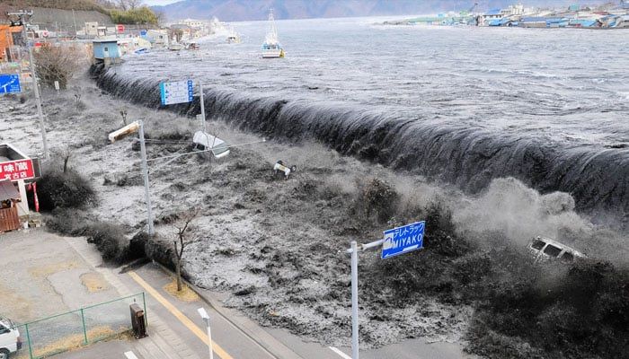
Given the magnitude and shallow depth, the quake initially raised fears of a tsunami, prompting alerts and immediate evacuations in coastal zones.

Tragically, at least two fatalities were confirmed. The casualties reportedly occurred in Mati City, in Davao Oriental province. The full scope of injuries and damage is still being assessed.
II. The Tsunami Alert: Issued, Feared, Then Lifted
A. Issuing the Tsunami Warning
Almost immediately after the quake, the Philippine Institute of Volcanology and Seismology (PHIVOLCS) issued a tsunami warning, advising that wave heights exceeding one meter above normal tides might strike nearby coasts.
The Pacific Tsunami Warning Center (PTWC) also flagged the possibility of hazardous waves for coasts within 300 km of the epicenter, extending the area of concern to parts of Indonesia and Palau. In some forecasts, waves between 1 to 3 meters were considered possible in the Philippines.
Evacuation orders were swiftly issued for coastal communities in provinces such as Eastern Samar, Dinagat Islands, Surigao del Norte, Leyte, Surigao del Sur, and Davao Oriental. Residents were urged to move inland or to higher ground.Boats at sea were instructed to stay offshore in deeper waters, and those moored were to be secured.

Urgency was high: the anticipated window for the arrival of tsunami waves was projected between 9:43 a.m. and 11:43 a.m. (local time).
B. Lifting the Alert
After hours of monitoring and measurement, the PTWC officially canceled the tsunami warning, indicating that the tsunami threat had passed. PHIVOLCS also adjusted its initial magnitude estimates and confirmed that sea level observations did not show destructive wave behavior.
While small fluctuations in sea levels were recorded in coastal areas, especially in Indonesia (with the highest measured deviation being about 17 cm) these did not reach dangerous or destructive thresholds.

With the alert lifted, residents were advised to remain vigilant, avoid returning to shorelines prematurely, and await local authority clearances before resuming normal activities in coastal zones.
III. Ground Impact: Damage, Disruption, and Human Consequences
A. Structural Damage & Infrastructure
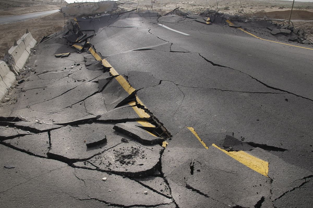
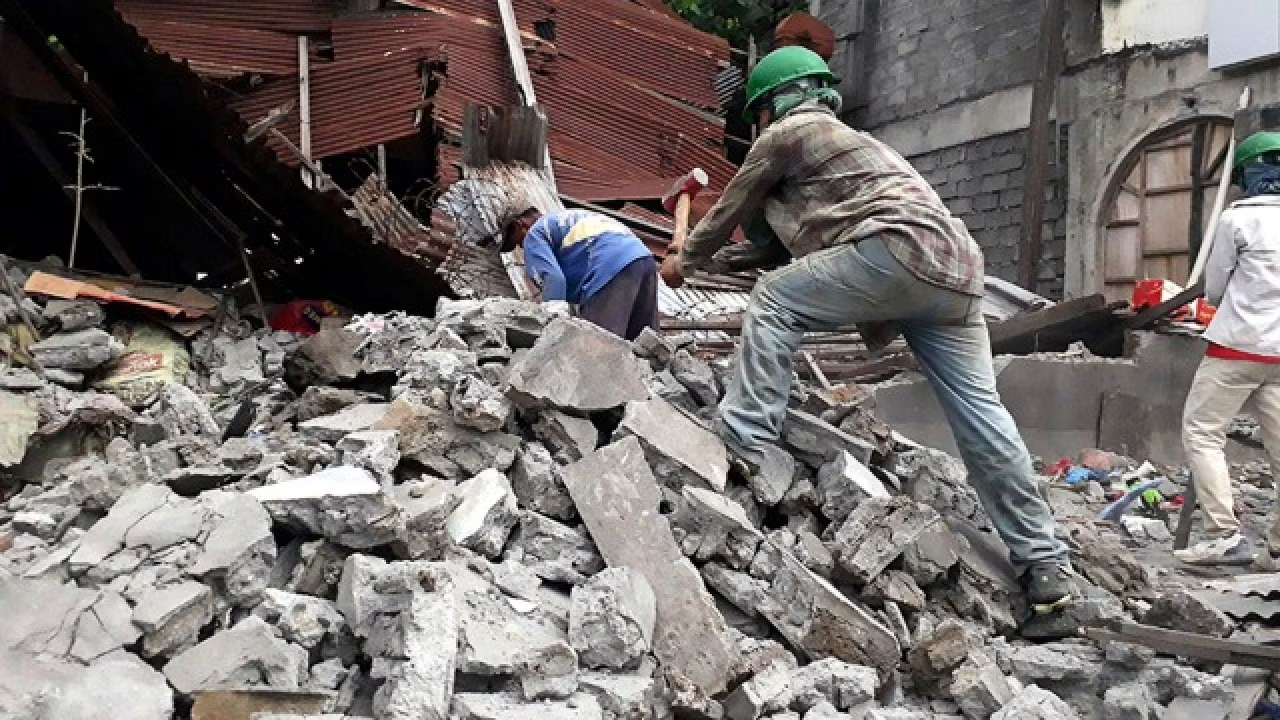
Buildings across the affected region sustained damage. Cracks appeared in residential walls, public buildings including schools were impacted, and ceilings in some offices fell or were damaged. Some infrastructure elements, such as bridges and transmission lines, reported harm or disruption.
In Gov. Generoso, a high school reported that as many as 50 students fainted or experienced dizziness — they were transported to hospital for observation.
In Davao City, classes were suspended, and school facilities closed temporarily to allow inspection for structural integrity.
Hospitals too were affected. At least one hospital was evacuated due to damage, as precaution, and critical patients were moved.
B. Utilities & Public Services
Power outages immediately followed the earthquake, as local electrical grids suffered disturbances. Repairs and restoration efforts were underway, but the extent and timeline varied across towns.
In some affected areas, communication lines and emergency systems were temporarily impacted, creating delays in relief coordination and severity assessments. (Inferred from typical post-quake conditions and initial reports of disruption.)
Transportation was also affected: some roads developed fissures, and local authorities inspected bridges and thoroughfares before allowing safe passage. Evacuation routes in coastal areas were critical and prioritized.
C. Human Toll and Response
At least two persons lost life, and multiple injuries were reported, though precise numbers are still unfolding.
Residents described panic, rushed exits from homes, people gathering in open spaces, and heightened anxiety in coastal towns.Many fled without belongings, hoping against the worst.
President Ferdinand Marcos Jr. addressed the nation, pledging rapid response. He directed various agencies — the National Disaster Risk Reduction and Management Council (NDRRMC), Office of Civil Defense, Armed Forces, Coast Guard, and local governments — to coordinate, assess damage, commence search and rescue, and deliver relief where needed.
Meanwhile, the Department of Social Welfare and Development prepared food, medical supplies, and basic essentials for displaced populations.
Local government units in coastal provinces mobilized evacuation centers, medical teams, and community volunteers.
IV. Scientific & Geotectonic Context
A. The Philippines & the “Ring of Fire”
The Philippines is situated along the Pacific Ring of Fire, a zone of high seismic and volcanic activity encircling the Pacific Ocean. As a result, it experiences hundreds of earthquakes annually — many minor, some powerful.
This recent quake is one in a series of strong tremors in recent weeks. Just days earlier, a magnitude 6.9 earthquake struck Cebu, causing dozens of deaths and renewed anxiety.
Geological faults in the region, including subduction zones, tectonic plate boundaries, and local fault lines, contribute to seismic hazards. Because many quakes originate offshore or near coastal trenches, tsunami risk is a perennial concern.
B. Magnitude, Depth & Risk
A magnitude of 7.5 at shallow depth (20 km) is especially dangerous: the shallower the quake, the more intense the shaking at the surface. In this event, the initial magnitude readings ranging from 7.2 to 7.6 were revised as agencies consolidated sensor data.
The quake’s location offshore meant that the energy release could travel into the sea and potentially trigger waves. This was part of the reason for issuing the tsunami alert. The depth and the geometry of the fault movement influence wave generation.
Aftershocks were expected, and some already registered magnitudes of ~5.6 or 5.9 in mid-morning.
Seismologists monitor such aftershocks, which can cause further damage or panic, especially in already weakened structures.
C. Tsunami Mechanics & Monitoring
Tsunamis are triggered when large displacements of the ocean floor occur — typically vertical movement along a fault line. Waves radiate outward, sometimes traveling great distances at high speed. Because the water depth is vast at ocean depths, waves might not seem large until they approach shallow coastal waters, where they amplify.
Early warning systems, such as PTWC and national agencies like PHIVOLCS, rely on seismometer networks, ocean buoys, coastal tide gauges, and computational models to estimate wave propagation, height, and arrival times. Evacuation orders are issued when the models suggest waves may exceed safe thresholds.
In this event, although forecasts predicted up to 3-meter waves in some zones, measured sea-level changes did not materialize to destructive levels, prompting cancellation of the alert.
V. Challenges, Lessons & Implications
A. Disaster Preparedness & Response Capacity
The quake underscores the ongoing challenge for the Philippines: how to rapidly mobilize search & rescue, medical assistance, and logistical relief, especially in remote or coastal areas. The ability to coordinate among national agencies, local governments, and international aid plays a crucial role.
Evacuation procedures, public education about tsunami risk, early warning dissemination, and rescue readiness all come under scrutiny in the wake of such events.
B. Infrastructure Resilience & Building Codes
Many structures in quake-prone regions are vulnerable. Damage to schools, hospitals, bridges, and homes suggests that infrastructure resilience is a continuing priority. Enforcement of stricter building codes, retrofitting older structures, and integrating seismic design into urban planning are essential to reduce casualties in future events.
C. Community Awareness & Evacuation Discipline
The efficacy of a tsunami warning depends heavily on how quickly and orderly residents respond. Panic, misinformation, or delays can worsen outcomes. Ensuring clear communication, trusted local agencies, and regular drills will strengthen response behavior.
D. Monitoring & Early Warning Systems
Continuous investment in instrumentation — seismic sensors, ocean buoys, tide gauges, satellite remote sensing — is vital. Refining models to reduce false alarms or overestimates (while preserving caution) helps maintain public trust.
E. Psychological Impact & Recovery
Beyond physical damage, the trauma to communities, particularly coastal towns where residents may lose homes or livelihoods, is profound. Mental health support, community rebuilding, and restoring stability are integral to long-term recovery.
F. Regional Coordination
Because tsunami warnings extended to Indonesia and Palau, the event demonstrates how seismic events in one region can have ripple effects across national borders. Regional cooperation in tsunami monitoring, data sharing, and coordinated evacuations is essential in the Pacific region.
VI. What Comes Next: Recovery, Assessment & Vigilance
-
Full Damage Assessment
Teams of structural engineers, geologists, and emergency responders will survey buildings, bridges, roads, schools, and hospitals to identify unsafe zones and priority repair sites. -
Restoring Utilities & Services
Electric grids, water systems, telecommunications, roads, and public services will be gradually restored. Priority is given to essential facilities like hospitals and evacuation centers. -
Continued Search & Rescue & Relief
Search efforts in collapsed or damaged structures, especially in remote or partially accessible zones, will continue. Relief distribution (food, medicine, shelter) will scale as access improves. -
Supporting Displaced People
Temporary shelters, medical aid, psychosocial counseling, and restoration of livelihoods will be critical for families forced out of homes. -
Aftershock Monitoring & Warnings
Authorities will remain on high alert for aftershocks. Monitoring seismic activity and reissuing local warnings if needed remains a priority. -
Review & Improvement of Response Protocols
The performance of warning systems, evacuations, interagency coordination, public messaging, and infrastructure resilience will be reviewed. Weaknesses will be addressed ahead of future events. -
Public Communication & Reassurance
Government leaders must keep communities informed, clear about safe return, and cautious about returning to vulnerable spots prematurely. -
Long-Term Mitigation Measures
Retrofitting buildings, enforcing seismic construction standards, expanding buffer zones in coastal areas, and continuing public awareness campaigns about quake and tsunami safety.