Introduction: Nature Wrecks Havoc Upon The Hills
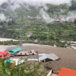
The irony, however, was that on August 5, 2025, a cloudburst over the Dharali town in Uttarkashi, a big tourist belt in the Indian state of Uttarakhand, triggered flash floods in the state where at least four people lost their lives with scores of others feared buried or missing. It went from the ordinary monsoon day to a scene of horror of collapsing hotels, submerged homes, and floods of people shouting, asking for help reverberating coming down the valleys.
The cloud burst in the Kheer Ganga river basin area which had holy confluences and serenity of Himalayas became fatal as it smashed down torrents of high speed water over the deep slopes of Dharali, a picturesque village, which was 8,600 feet above the sea level.
Latest News Updates: This area is one of the most important points of the spiritual and Eco-tourism circuit in Uttarakhand as pilgrims visit this area on the way to Gangotri and further on. Dharali is also strategically used in terms of disaster preparedness that is border sensitive considering its strategic location towards the northern frontier of India.

Timeline of Events: The Disaster Unfolds
Afternoon, August 5, 2025
- Sudden heavy rainfall was recorded in parts of Uttarkashi district around 2:15 PM.
- The Kheer Ganga river, which is an ordinary stream and flows into the Bhagirethi, located itself in a short time as a raging roaring water flow.
- Locals reported at 2:45 PM giant waves rolling down the hills, engulfing hotels and the central market of Dharali therein.
- Eyewitness videos portrayed buildings falling in the face of the deluge with people frantically screaming and running.

Further Deterioration: ISRO satellite images of Cartosat series further confirmed the intensity of the cloudburst in a narrow band of 8-10 Km, which is typical of the high altitude microburst pattern frequently associated with intense monsoonal convection.
Evening – Emergency Response Begins
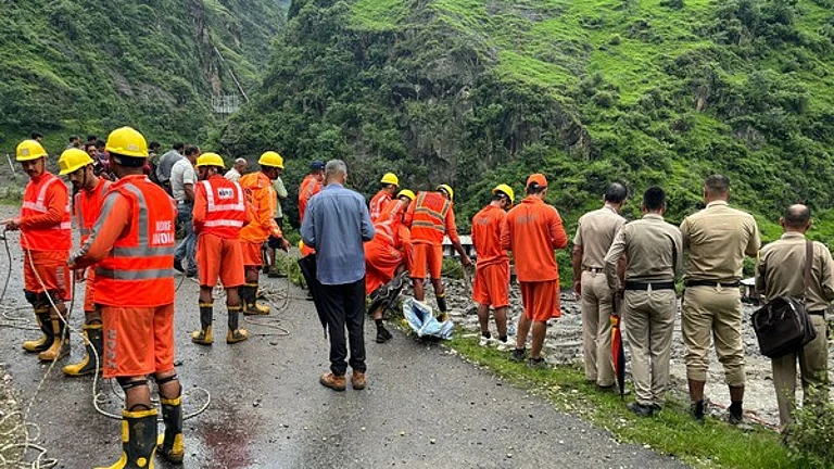
- At 4:30 PM, the district administration had started rescue work with NDRF, SDRF and local police teams.
- As visibility improved, helicopters were used out of Air Force Station Sarsawa.
- Makeshift relief centers were established at Harsil and Uttarkashi towns to organize the relief.
During the night, more than 12 sorties were flown, thermal plastic blankets, ration kits, and needed medications were air-dropped. The communication network, which includes emergency systems, partially worked in Uttarakhand because the infrastructure was resilient, which was introduced after the 2021 Chamoli disaster.
Scale of Damage: Life and Infrastructure Lost
According to official estimates by the Uttarkashi District Magistrate’s Office, the flash floods caused:

- Four people died with bodies retrieved in debris-covered places around the bank of the river water.
- About 60-70 people have remained unaccounted for or buried under rubbles.
- More than 25 buildings such as guest houses, hotels, and personal homes were totally washed away.
- At least three villages were destroyed; the villages are Dharali, Harsil and Bagori where power lines, roads, and communication infrastructure were destroyed.
General Impact: The route of Char Dham Yatra has been badly affected. Buses to Gangotri have been stopped at safer points in Uttarkashi. Telemetry has been influenced by power failure of telemetry stations in monitoring glaciers which may set back the urgently needed information on the river trend.
Human Stories: Survival Amidst Chaos
Those who survived it include residents such as Ramesh Negi, who was a hotel manager whose entire livelihood was destroyed in Minutes when the flood came:
“It was like a wall of water. I was just delivering tea, the next thing I noticed the glass windows breaking. My guests ran out barefoot, screaming.”
Described Kavita Rawat, another survivor whose two young children remain unaccounted:

“We heard a roaring sound. I took my little boy, but my daughter and husband were behind. I haven’t seen them since.”
New Testimony: Nitin Sharma of the SDRF, a rescue worker, told:
Two kilometers down the river we found a child hanging on a tree. He had been deprived of his whole family yet he had hope. This is the type of heartbreak that we have here.”
Center and State Respond: Political and Administrative Moves
Immediately Prime Minister Narendra Modi, Union Home Minister Amit Shah, and Defence Minister Rajnath Singh called Uttarakhand Chief Minister Pushkar Singh Dhami, assuring all possible support.

A statement by the PMO has indicated:
- The armed forces and NDRF are being deployed in all possible ways. The families affected are in our prayers. It is monitored hour-by-hour for relief and rescue.”
- Early on August 6, Chief Minister Dhami arrived by helicopter in Uttarkashi where he flew aerial surveys and announced a special relief package which included:
- Alleviation of 10 lakh compensation to families of dead ones
The injured will receive 2 lakh
Imminent relocation camps and food items to more than 300 displaced families
Further Development: The Union Government also reactivated the National Disaster Response Framework Tier-II for the emergencies faced on high altitude ecological emergencies. The cut-off segments near Gangnani have been mobilized into the Border Roads Organisation (BRO) to restore the same.
Climate Warning: A Symptom of a Larger Ecological Crisis?
Environmental scientists have cautioned that higher frequency of cloudbursts in Uttarakhand are pointers to the current climate change, deforestation and uncontrolled construction in sensitive ecological zones.
According to a geologist at Wadia Institute of Himalayan Geology, Dr. Neha Chaturvedi confirmed:
There has been massive human encroachment on the river basin of Kheer Ganga. The loss of vegetation has reduced the soil’s absorption capacity, making such flash events more destructive.”
Uttarakhand has experienced more than 47 cloudbursts since 2010 and this figure includes numerous instances in the Char Dham route – the clear indication that
climate-resilient urban planning and the early warning systems is no longer a luxury, but a must.
Wider scope: Himalayas rainfall disparities have in recent studies been coupled with the north Atlantic oscillation patterns by the National Institute of disaster management (NIDM) with surface temperature increase of the Indian ocean adding to the problem.
Emergency Measures: What’s Being Done Now?
Its helicopters with the Indian Air Force are evacuating stranded locals and tourists in Dharali and other hillsides.
- ITBP units have come up with makeshift bridges and rope crossings to reach out to isolated hamlets.
- AIIMS Rishikesh medical teams have been airlifted for trauma care.
- Water and food kiosks established by the local volunteers and NGOs are on the outskirts of Uttarkashi town.
Long-term Action Plan:
- Mapping of the debris fields through drones has been started.
- The Center for Disaster Mitigation at IIT Roorkee is placing mobile seismic sensors in the terrain to track instability.
- ITBP has been given the mandate to clear the mule pathways to deliver food when cross-road becomes unattainable.
Ongoing Challenges
Authorities also face major difficulties even as they seek immediate solutions:
- Relief is being slowed by blocked roads and landslides.
- Parts of Gangotri valley lack mobile signals which inhibits coordination.
- There is still great fear of after shocks or secondary landslides of the soil getting saturated.
Added Complexity: The tourism firms have reported 22 trekkers missing, among them were 6 foreigners. In the meanwhile, loss of livestock in the vicinity is claimed to be 50 lakh and more, which has a direct impact on the agrarian economy of the hill communities.
More Read

National Attention and Call for Sustainable Development
The Uttarkashi tragedy has rekindled the arguments of uncontrolled tourism, development of infrastructure in the Himalayan fringe, and inadequate planning which is climate-adaptive. Since the 2013 Kedarnath disaster and the 2023 Joshimath land subsidence, this incident serves as one more sad example of how imbalanced building comes at a price.
Environmentalists are calling upon the government to:
- Improve disaster forecasting apparatuses.
- Establish buffer zones in eco sensitive areas
- Prohibit building in vulnerable riverbanks
- Use local knowledge in disaster planning
Policy Urgency: The current proliferation of Geospatial AI models is compelling the Uttarakhand State Disaster Management Authority (USDMA) to implement Geospatial AI models in the early warning of risk. Environmental NGOs are seeking a cessation of new hydropower clearances in sensitive catchments.
A Tragedy That Must Wake Us Up
Even as the rescue operations go on in Dharali, where the families wait helplessly to hear about their relatives; the Uttarkashi cloudburst has once again put the country in shock. It has also demonstrated to us how vulnerable the ecosystems of the mountain are, and precisely what a costly mistake it is to ignore the warnings of the natural world.
However, the numbers aside, it is also the story of real individuals, the stories of families that have been destroyed, with dreams swept clean away, and a community now having to pick up the pieces after the disaster.
Make this headline not just deja vu. Through this, may this mark a time India starts the process of treating its mountains the way it should deservedly be treated- as not merely a tourist destination, but a living, breathing path to our own futures.